 Catalogue PIGMA
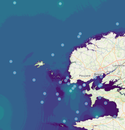
WP3 Pelagic Mapping
Type of resources
Available actions
Topics
Keywords
Contact for the resource
Provided by
Years
Formats
Representation types
Update frequencies
status
Scale
Resolution
-
Quonops Online Services provide noise monitoring and prediction tools. In a similar manner to weather forecasting systems, Quonops© produces an estimate of the spatio-temporal distribution of noise levels generated by human activities at sea, aggregating multiple sources, and assessing short-, mid- and long-term source contributions to the global noise field. The outputs from Quonops© are tailored to the requirements of existing and emerging national and international regulations regarding: - Underwater noise. - The conservation of habitats and marine ecosystems. - The protection of marine species. Such tools aim to support management decisions by assessing, quantifying and prioritizing direct and indirect anthropogenic pressures on marine life, according to regulations on underwater noise, especially the descriptor 11 of the European Marine Strategy Framework Directive.
-
GBIF, the Global Biodiversity Information Facility, is an international network and data infrastructure funded by the world's governments and aimed at providing anyone, anywhere, open access to data about all types of life on Earth. Coordinated through its Secretariat in Copenhagen, the GBIF network of participating countries and organizations, working through participant nodes, provides data-holding institutions around the world with common standards and open-source tools that enable them to share information about where and when species have been recorded. This knowledge derives from many sources, including everything from museum specimens collected in the 18th and 19th century to geotagged smartphone photos shared by amateur naturalists in recent days and weeks. The GBIF network draws all these sources together through the use of data standards, such as Darwin Core, which forms the basis for the bulk of GBIF.org's index of hundreds of millions of species occurrence records. Publishers provide open access to their datasets using machine-readable Creative Commons licence designations, allowing scientists, researchers and others to apply the data in hundreds of peer-reviewed publications and policy papers each year. Many of these analyses, which cover topics from the impacts of climate change and the spread of invasive and alien pests to priorities for conservation and protected areas, food security and human health, would not be possible without this. GBIF arose from a 1999 recommendation by the Biodiversity Informatics Subgroup of the Organization for Economic Cooperation and Development's Megascience Forum. This report concluded that "An international mechanism is needed to make biodiversity data and information accessible worldwide", arguing that this mechanism could produce many economic and social benefits and enable sustainable development by providing sound scientific evidence.
-
OBIS is a global open-access data and information clearing-house on marine biodiversity for science, conservation and sustainable development. VISION: To be the most comprehensive gateway to the world’s ocean biodiversity and biogeographic data and information required to address pressing coastal and world ocean concerns. MISSION: To build and maintain a global alliance that collaborates with scientific communities to facilitate free and open access to, and application of, biodiversity and biogeographic data and information on marine life. More than 20 OBIS nodes around the world connect 500 institutions from 56 countries. Collectively, they have provided over 45 million observations of nearly 120 000 marine species, from Bacteria to Whales, from the surface to 10 900 meters depth, and from the Tropics to the Poles. The datasets are integrated so you can search and map them all seamlessly by species name, higher taxonomic level, geographic area, depth, time and environmental parameters. OBIS emanates from the Census of Marine Life (2000-2010) and was adopted as a project under IOC-UNESCO’s International Oceanographic Data and Information (IODE) programme in 2009. Objectives - Provide world’s largest scientific knowledge base on the diversity, distribution and abundance of all marine organisms in an integrated and standardized format (as a contribution to Aichi biodiversity target 19) - Facilitate the integration of biogeographic information with physical and chemical environmental data, to facilitate climate change studies - Contribute to a concerted global approach to marine biodiversity and ecosystem monitoring, through guidelines on standards and best practices, including globally agreed Essential Ocean Variables, observing plans, and indicators in collaboration with other IOC programs - Support the assessment of the state of marine biological diversity to better inform policymakers, and respond to the needs of regional and global processes such as the UN World Ocean Assessment (WOA) and the Intergovernmental Science-Policy Platform on Biodiversity and Ecosystem Services (IPBES) - Provide data, information and tools to support the identification of biologically important marine and coastal habitats for the development of marine spatial plans and other area-based management plans (e.g. for the identification of Ecologically or Biologically Significant marine Areas (EBSAs) under the Convention on Biological Diversity. - Increase the institutional and professional capacity in marine biodiversity and ecosystem data collection, management, analysis and reporting tools, as part of IOC’s Ocean Teacher Global Academy (OTGA) - Provide information and guidance on the use of biodiversity data for education and research and provide state of the art services to society including decision-makers - Provide a global platform for international collaboration between national and regional marine biodiversity and ecosystem monitoring programmes, enhancing Member States and global contributions to inter alia, the Global Ocean Observing System (GOOS) and the Global Earth Observing System of Systems (GEOSS)
-
Accredited through the MEDIN partnership, and core-funded by the Department for the Environment, Food and Rural Affairs (Defra) and the Scottish Government, DASSH provides tools and services for the long-term curation, management and publication of marine species and habitats data, within the UK and internationally. Working closely with partners and data providers we are committed to the FAIR Data Principles, to make marine biodiversity data Findable, Accessible, Interoperable and Reusable. DASSH is a flagship initiative of the Marine Biological Association (MBA), and builds on the MBA's historic role in marine science. Through partnerships with other UK and European data centres DASSH contributes to data portals including the NBN Atlas, EMODnet, EurOBIS and GBIF. Fill out a form into the website to generate monthly lifeform abundances from the selected dataset.
-
EMODnet Biology provides three keys services and products to users. 1)The data download toolbox allows users to explore available datasets searching by source, geographical area, and/or time period. Datasets can be narrowed down using a taxonomic criteria, whether by species group (e.g. benthos, fish, algae, pigments) or by both scientific and common name. 2) The data catalogue is the easiest way to access nearly 1000 datasets available through EMODnet Biology. Datasets can be filtered by multiple parameters via the advanced search from taxon, to institute, to geographic region. Each of the resulting datasets then links to a detailed fact sheet containing a link to original data provider, recommended citation, policy and other relevant information. Data Products - EMODnet Biology combines different data from datasets with overlapping geographic scope and produces dynamic maps of selected species abundance. The first products are already available and they focus on species whose data records are most complete and span for a longer term.
-
FishStatJ is a Windows and Mac application that anyone can use to access FAO’s Fisheries and Aquaculture statistics. They include datasets on production, trade and consumption. Data can be extracted and aggregated according to different level of details and international standard classifications. It consists of a main application and several workspaces that include the datasets.
-
The European Tracking Network (ETN) aims at bringing together marine researchers based in Europe that use aquatic biotelemetry as a tool. The main goals of the network are the promotion of transboundary cooperation, the establishment of a pan-European aquatic telemetry infrastructure network, improved data sharing through a central data portal and enhanced funding opportunities. ETN is co-coordinated by IMAR/University of the Azores and the Canadian Ocean Tracking Network (OTN) initiative. ETN is a partner node of OTN. The central data platform is hosted by the Flanders Marine Institute (VLIZ) and provides three key services to the users. 1) Data and metadata are stored centrally at a PostgreSQL database. To facilitate the data entry and data management for the users, a web application was developed in PHP using Symfony framework. 2) A data explorer is available to visualize the data. Datasets can be filtered based on area, species or time frame. In addition, detection data can be linked to other data types ( (e.g. moon index and tides) and several plot options are available. 3) In the R-studio environment, more detailed analyses can be performed.
-
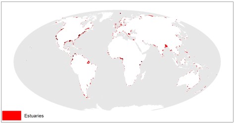
This dataset shows the global distribution of over 1,300 estuaries, including some lagoon systems and fjords. The majority of estuaries are represented by polygons, except for 44 records for which points are available. This dataset was developed by Sea Around Us (www.seaaroundus.org).
-
The Surface Ocean CO₂ Atlas (SOCAT) is a synthesis activity for quality-controlled, surface ocean fCO₂ (fugacity of carbon dioxide) observations by the international marine carbon research community (>100 contributors). SOCAT data is publicly available, discoverable and citable. SOCAT enables quantification of the ocean carbon sink and ocean acidification and evaluation of ocean biogeochemical models. SOCAT, which celebrated its 10th anniversary in 2017, represents a milestone in biogeochemical and climate research and in informing policy. SOCAT data are released in versions. Each succeeding version contains new data sets as well as updates of older ones. The first version of SOCAT was released in 2011, the second and third version followed biennially. Automation allowed annual public releases since version 4. The latest SOCAT version (version 2022) has 35.6 million observations from 1957 to 2022 for the global oceans and coastal seas. 7.2 million calibrated sensor observations are also available. SOCAT version 2023 was released on the 20th of June 2023, containing data submitted on or before 15th of January 2023. New data submissions are welcome at any time, and will be included in the next SOCAT release. The submission deadline for v2024 is 15 January 2024. SOCAT is a core Global Ocean Observing System data product for biogeochemistry endorsed by the Global Ocean Observing System GOOS.
-

The Plankton Lifeform Extraction Tool brings together disparate European plankton datasets into a central database from which it extracts abundance time series of plankton functional groups, called “lifeforms”, according to shared biological traits. This tool has been designed to make complex plankton datasets accessible and meaningful for policy, public interest, and scientific discovery. The Plankton Lifeform Extraction Tool currently integrates 155 000 samples, containing over 44 million plankton records, from nine different plankton datasets within UK and European seas, collected between 1924 and 2017. Additional datasets can be added, and time series can be updated.